
Digital Road Network (DRN) data requirements
On this page:
About
QRA relies on Digital Road Network (DRN) data from applicant organisations (councils and state agencies) to verify the location of transport infrastructure and assist in assessing eligibility of assets for funding relief under the Commonwealth Disaster Recovery Funding Arrangements (DRFA) Reconstruction of Essential Public Assets (REPA) and Immediate Reconstruction Works (IRW).
Once provided to QRA, each Organisation’s current DRN data is uploaded in the MARS Portal to view the assets on a digital map. This mapping integration also enables geospatial validations in MARS to assist applicants in quality checking data and evidence, and resolving validations prior to lodging each REPA or IRW funding submission.
DRN ready before each disaster season
Before each disaster season, or prior to developing and lodging your first submission in a financial year, all organisations are urged to check the currency of their DRN in MARS, and where required send any DRN changes to QRA. DRN changes may include:
- new assets
- removed assets
- changes to an existing asset e.g. name, asset Id, chainage recalibration, asset length extension.
Before undertaking damage assessments of event damaged roads, organisations must ensure the same DRN dataset is provided to both QRA and, any third-party vendor. This will ensure MARS displays and validates the same dataset used for the event damage pickup, ready to support a smooth submission lodgement and assessment process.
Note: submissions created using inaccurate DRN data will need to be rectified, delaying assessment and approval process, often resulting in the need to withdraw a submission, update the DRN data and re-lodge the submission.
DRN data requirements
All DRN spatial data provided to QRA should include:
- road centreline spatial data and/or
- chainage point dataset in metres (whole numbers).
- unique road name with correct spelling
- unique asset ID
- start and end chainage values (in metres).
Detailed requirements
QRA considers the following to be minimum standards of road centreline data:
- all road assets are a single centreline
- segmented centrelines will be accepted but they must have a field designating the entire asset (i.e. asset ID and/or road name)
- a unique asset ID for each road asset (single centreline)
- all roads have a unique name with correct spelling.
- to make a road name unique, QRA suggests using the asset ID e.g. Smith Street QRA123
- MARS is case sensitive meaning spelling, case and symbols must be an exact match between the DRN and your submission
- when separating sections of the asset name, QRA recommends using underscore, hyphen or single spaces only.
- dual carriageways can be one of the following options:
- two centrelines with separate name and asset ID for each direction for example:
- “Major Road (Northbound)” – Asset ID 1234_N
- “Major Road (Southbound)” – Asset ID 1234_S
- two centrelines with separate name and asset ID for each direction for example:
- one centreline with single name and asset ID for example “Major Road” 1234.
TIP – When updating your organisation’s DRN, only update an asset name from the MARS DRN where needed. Changing asset names can impact submissions already lodged and in delivery.
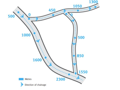
To accompany the road centreline data, an organisation can supply chainage point dataset at regular intervals i.e. 100m points (metres in whole numbers).
This can calibrate long roads (> 10km) as hills or valleys will make chainage longer than the centreline length. We can use chainage points to ensure our DRN chainage for each asset exactly matches that of the chainage points supplied by council.
All chainage data must include unique asset name and/or asset ID to link back to the road centreline.
NOTE: To ensure streamlined submission lodgement, assessment and approval, it’s important that damage pick up activities and QRA submission assessment are using the same centreline and chainage dataset. If third-party software or resources are employed to capture damage data, make sure you supply the same DRN data set (centreline and chainage) to QRA.
Annual DRN checklist
- Step 1 - Request DRN data export
Contact your Regional Liaison Officer to request an export of your organisation’s MARS DRN. This includes a spatial centreline and/or chainage points if requested (ESRI file) and excel.
- Step 2 - Review and update data
Review the MARS DRN data and identify any changes. DRN changes may include
- new asset
- removed asset
- change to an existing asset e.g. name, asset ID, chainage recalibration, asset length extension.
Note – it is recommended not to change an asset name or asset ID in the MARS data unless necessary as this can impact submissions.
- Step 3 - Data format
Supply all spatial data in the following format:
- ESRI file GDB or shapefile, and/or
- Chainage points.
- Step 4 - Complete and return
Double check the updated data meets the detailed DRN data requirements in this tip sheet. Do a final check that asset names and asset ID are unique and matching the MARS DRN dataset.
Send the updated road asset information to support@qra.qld.gov.au and cc to your RLO.
- Step 5 - Confirm data is correct
Once QRA undertakes the data checks, the GIS team will send back the updated DRN that will be updated in MARS for confirmation from the organisation that the data is correct. Once this confirmation has been received the DRN data will be updated into MARS.
- Step 6 - DRN is updated in MARS
Once your organisation’s DRN has been updated in MARS, It will be available for you to view in the MARS portal. For any submission that is currently in draft you will need to re-select the asset and validate the submission.
Questions and answers
QRA completes a number of data checks to ensure the organisation’s DRN data is as accurate as possible prior to upload into MARS. These checks include:
- identifying duplicate asset names. For example, if there are two streets called “Smith Street” in an LGA but in different locations, QRA will highlight for the organisation to resolve
- ensuring there is a unique Asset ID for each road
- checking chainage accumulates in a uniform direction, as directed by the draw direction of the supplied centrelines, and, the organisation’s point chainage data.
- applying a chainage where data is not supplied. QRA will apply a chainage based on the line draw direction and total length of asset, and start and end chainage value.
The QRA GIS team will supply feedback on these checks for the organisation to amend if required, if the data meets the checks the organisation can confirm that the data can be uploaded into MARS.
An organisation can update one or more roads that may need resolving to meet the validation requirements of a submission. This can make the DRN update a quick process to expediate your submission lodgement.
Yes. MARS is a portal for building and lodging submissions to QRA and is not intended to replace essential systems within each organisation. It is still the responsibility of each organisation applying for disaster funding to maintain and store all relevant data sets and documentation.
Yes. Once the organisation provides the relevant DRN data associated with the asset it maintains outside its local government area, with a copy of the joint written agreement with the neighbouring council or State agency for the specified period, QRA will work with both organisations to update the DRN locations according to the joint agreement. Updating the data correctly will also support MARS asset validation messages
All organisations should check the DRN in MARS as part of pre-season preparedness each year.
Yes, you can send through a request to update a road that is not in your organisation’s DRN in MARS. When this road has been updated into the system you will then need to revalidate the submission.
Send the updated road asset information based on the above requirements to support@qra.qld.gov.au and your RLO.
| Need Help? | Email QRA support@qra.qld.gov.au and cc to your QRA Regional Liaison Officer (RLO) |
Print version PDF
QRA Reference: DOC/20/12197 Version 2: August 2023